Final thoughts on Namibia then onward to Botswana

Namibia was an amazing experience for both the driving conditions and the varied landscape.

We drove 4,959 kms of which 80% was gravel, washboard and very dusty roads.

Each evening when we set up camp we had to dust off the interior of our truck, comb the dust out of our straw hair and shake clouds of dust out of our sheet and blankets. I don’t want to say this isn’t for the faint of heart but the driving conditions were very challenging and a flat tire or breakdown was always at the back of our minds.

We drove for many hours without any sign of civilization or other vehicles and were always in awe at the amazing scenery that rattled by. The days were hot and sunny and most evenings pleasant although some nights were very cold but a fire at the end of a long day warmed up the rattled bones and our bed was cozy and comfortable.

Our camp sites ranged from the very basic to basic usually with a nearby lodge serving up dinner and drinks. Most were in the wild with the potential of wild animal visitors. All were in spectacular settings and the star gazing in night skies was absolutely incredible.

It is difficult to put this country into words, the second largest in Africa with a population of just 2 million people all of whom were warm, friendly and helpful. One special new friend was made in Sossusvlei. His name is Fanuel and we met him at the Sossus Dune Lodge. He had an engaging personality and was always kind and helpful. He will do well in the future.

You can easily get lost in Namibia (especially because of the lousy map we had) but you also lose yourself in the vastness and beauty that passed by everyday of our adventure in this vast frontier.

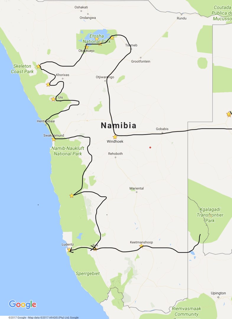
Below is a map of our journey through Namibia and some road pictures from our iPhone. Please note the obligatory injuries that Joyce sustained while descending a rocky mountain trail in Twylefontaine after visiting the petroglyphs. Fortunately no bones were broken and it could easily been much more serious.
File_000

Etosha National Park

Etosha National Park

Etosha National Park was proclaimed a national park in 1907 and spans 22,270 square km’s. It gets its name from the large Etosha Pan which is almost entirely within the park. The park is home to hundreds species of mammals, birds and reptiles, including several endangered species such as the black rhino. We spent 3 days at 3 different camping sites throughout the park. We have never seen so many herds of zebra mixed in with wildebeest, elephant, oryx, springbok, ostrich and many others. It was very dry yet full of life.

Palmwag to Etosha National Park

Palmwag to Etosha

Arrived  today into Etosha National Park.

Twyfelfontaine to Palmwag (Damarland)


Twyfelfontaine to PalmwagArrived in Palmwag on the 3rd after probably the most bone wrenching drive so far. We’re surprised we haven’t had any flat tires yet but we passed several travellers who did. The driving in Namibia is an adventure in itself. You really don’t know what lies around each bend, deep dip, washboard and tight curves in the road. There are no towns or villages for hundreds of km to speak of. Just vast open desert, scrub and mountains. It is truly beautiful but harrowing.

Our camp was private and secluded and was located on an elephant path leading from a semi marshy reed and palm tree filled gully and to our delight, after dinner while sitting around our fire the resident old bull elephant wandered unannounced into our campsite. A site to behold. He was huge! The biggest we have seen and he casually munched on some nearby brush while Joyce scrambled to get the cameras. We followed him within metres and I was able to get a bit of video using my flashlight to illuminate him in the darkness. The elephant pictures didn’t turn out so just two pics of the palms.

Brandberg to Twylefontaine (Damarland)

Brandberg to Twyfelfontaine

We headed north-west on August 2nd to Adabi Mountain Camp. Another beautiful camp along another dry river bed. This place was rustic with no electricity, outdoor bush bathrooms and showers and the flies were a royal pain in the ass but the scenery and location more than made up for this small nuisance. In the early afternoon we were waiting in the “bar shack” for our driver to take us to the Twylefontain petroglyphs, a World Heritage Site when a van pulled up, 5 dusty and thirsty people disembarked, ordered 5 beer and immediately we knew the evening ahead would be fun. They were a mixture of Spaniards, Portuguese and British and were the first group of people who we met who were engaging, funny, adventurous, laid back and liked a drink or two. Needless to say the evening pre dinner drinks and dinner conversation was a hoot. They were very nice people and we wish them well.

Swakopmund to Damarland(Brandberg)

Swakopmund to Brandberg

Departed Swakopmund August 1st and headed north along the Skeleton Coast on a smooth salt highway. A very nice change from the bone rattling gravel roads we’ve driven so far in Namibia. The road was straight and the landscape desolate desert on one side and the cold crashing Atlantic Ocean on the other.  We stayed at Brandberg White Lady Camp, a very nice camp along a dry river bed and before setting up camp were greeted by a small herd of elephants meandering through a nearby camp site and some unruly mules adding to the excitement.

Sossusvlei to Swakopmund

Sossusflei to Swakopmund

The lalalong, bababumpy road to Swakopmund!

Aus to Sossusvlei

Aus to Sossusflei

We arrived in Sossusvlei on July 27th and spoiled ourselves for three nights at the Sossu Dunes Lodge.

Sossusvlei is located in the Namib Desert in the Namib-Naukluft National Park, the largest conservation area in Africa, and boasts some of the highest sand dunes in the world, some reaching up to 400 metres. The red sand makes for spectacular photography, especially in the early morning or late afternoon.

On the morning of the 28th, we drove 60 km to the dunes, where we hiked about 1 km to reach some of the dunes in the photos and attempted to climb them, but it was extremely hot and dry, and heart attacks are not in our itinerary.


The next day, we visited Sesriem Canyon, located less than 1 km from our lodge in the park. The canyon’s birth dates back between 2 and 4 million years, when continental upheaval resulted in the creation of most of the westward-flowing rivers in the Namib Desert region. Today, the Tsauchab River only runs after good rains fall in the nearby Naukluft Mountains.

The canyon is a testament to the river’s long-past prime some 15-18 million years ago, when the gorge was created by the river’s once-sweeping movement. The canyon is up to 30 metres deep at points and is roughly 1 km long, with a width that ranges between 1 and 3 metres, flattening out as it approaches the iconic Sossusvlei.


Quiver Tree Forest to Aus and Kolmanskuppe/(Kolmanskop)

Keetmanskop to Aus

We arrived at Aus-Klein Vista camp located just outside the town of Aus on July 26th.

Aus is located in the Aus Mountains above the plains of the Namib desert and the village was formerly the site of a prisoner of war camp in 1915 used to house German inmates from the First World War.

Our campsite was fantastic, private yet exposed to the local wildlife. Oryx, ostrich and springbok wandered and fed nearby.

We arrived fairly early in the day, so we headed out on a 2-hour hike up through a rock-strewn mountain path to arrive at the most incredible view of the plains of the Namib Desert far below.

Later in the evening, we cooked pork chops over a wood fire while watching springbok feed nearby. After Joyce went to bed with her hot water bottle, I sat by the fire contemplating life, the universe and everything, like I usually do when staring at the stars.

I occasionally shone my flashlight around the surrounding area, and to my delight, an African wildcat approached my spotlight. It was about four times the size of an average house cat and, of course, I didn’t have a camera on hand. We definitely made eye contact, as we were only about 15 feet apart from each other. A very cool experience.


The next day, we had a very long journey ahead of us, but we definitely had to go about 200 km out of our way, round trip, to visit the famous ghost town of Kolmanskop, once called “the African Siberia,” where once upon a time many people found wealth in diamond mining.

Most of the houses and buildings were constructed between 1908 and 1910 and now stand abandoned and are slowly being reclaimed by the desert sands. The wind was howling, and after a very short time, we were covered in a fine sand dust. My camcorder shutter became jammed, and our trip back to Aus to continue on to Sossusvlei would become an adventure we didn’t anticipate.


Backtracking to Aus, the wind blew waves of sand across the highway, which was fortunately paved and smooth going. The wind was strong, but I didn’t think it was so strong that it would cause the truck to become sluggish climbing a small hill. After several cars flashed their lights at us and I realized I had the gas pedal to the mat, we figured something was definitely not right. So we pulled over in the middle of nowhere to check things out.

Well, damn! The pop-top of the truck had popped up and the tenting canvas was in tatters. Shit, both of the top latches had released. Well, not quite. One latch released while the other had literally ripped out of the steel-moulded canopy top. Now what? What do we do? How do we get back to Aus? (Good thing Aus isn’t spelled OZ, ha ha!).

We had some thick string that we used to secure our water supply (another story), but no way would it be strong enough to secure the pop-top. I put on my MacGyver cap, thought holy crap, now what, but didn’t say this out loud because Joyce was, shall we say, a little panicked, and came up with a plan. We had a tow rope stowed in the truck. Hopefully, it would be long enough to secure the top and get us back to town. It was, just barely, within inches, but it worked.

We slowly headed back to Aus, bought a strap and ratchet at the local gas station, secured the top, and made our merry way for the next 5 1/2 hours, driving several hell-highways en route to Sossusvlei.

It took 1 1/2 days for a technician to meet up with us in Sossusvlei. He fixed everything, and now we will be paranoid for the rest of our trip. What will happen next?

The road back to Aus.


First stop, Quiver Tree Forest, Keetmanskop

Namibia

Flag of Namibia

First stop, Quiver Tree Forest, Keetmanskop

July 30, 2017

Kgalagadi to Keetmanskop

We departed Kgalagadi Transfrontier Park in SA on the 25th and endured 340 km of bone-wracking gravel roads leading us to the Quiver Tree Forest Rest Camp.

We stayed one night and nearly froze to death in the cold wind that blew through the desert landscape. The wind was so strong we could hardly keep the fire going, so we settled on a package of soup mix and an unknown type of sausage/hot dog that we grilled on a fork over the smoking, blowing fire. The smoke infiltrated every fibre of our clothing and camper truck. Needless to say, my copilot was not too happy, so I filled the hot water bottle and sent her off to an early 8:00 pm bedtime.

The quiver tree is one of the most interesting and characteristic plants of the very hot and dry parts of Namibia and the northwestern part of the Cape Province of South Africa. It is not actually a tree but an aloe plant. The plant is called a “Kokerboom” and was named as such because some Bushmen and Hottentot tribes used the tough, pliable bark and branches to make quivers for their arrows. “Koker” is the Afrikaans word for quiver.